Demapping Planning
 At the recent Brooklyn Borough Atlantic Yards Committee’s meeting, Winston Von Engel from City Planning was asked what the department’s position on demapping streets is. His initial reply: "I don't think there's one policy for demapping or mapping streets". Spectacularly unhelpful. And then, according to Norman Oder in the TimesRatnerReport, Von Engel continued:
"In Downtown Brooklyn, we demapped streets to create more rational building sites, more rational blocks, because the leftover remnants were not lending themselves to be building on. But in other cases, we've mapped streets back and we appreciate the life that streets bring. There is no one set policy."
OK, both happen. But that doesn’t mean that there is no policy. In fact there is a policy, and we know what it is: agree to demap streets only if doing so supports sound urban design principles. City Planning’s public silence in the wake of the planning failure at Atlantic Yards is uncharacteristically deferential to the developer, at the expense of the public realm. Was Von Engel’s statement that the city has supported demapping streets in Downtown Brooklyn a reference to the changes in the Downtown Brooklyn plan in which "several street map changes are proposed to create larger, more viable development sites, to improve traffic flow and to provide landscaped street medians. These actions include closing some low-volume streets and extending and widening some other streets", or the 2003 demapping of portions of Pearl and Adams Streets to expand the Brooklyn Marriott Hotel? There the 1,025 square feet at the end of Pearl was already a dead-end, used only for on-street parking. And the 3,395 square foot sliver of Adams was a non-traffic remnant of a 1940’s street widening. These actions are in no way similar to the proposed demapping of approximately 70,000 square feet of Pacific Street between Carlton and Vanderbilt.
Pacific is far from a low-volume street, or a short dead end street. And the blocks on either side are already very large, approximately 200 feet wide and 1000 feet long, certainly not irrational for building sites. Demapping this section of Pacific would form an enormous superblock of perhaps 470,000 sf, over 10 acres. In many ways, the issues here are similar to the issues at the former World Trade Center superblock. The Chair of the City Planning Commission and Director of the Department of City Planning, Amanda Burden, recently addressed those streets and blocks in an open letter to the LMDC:
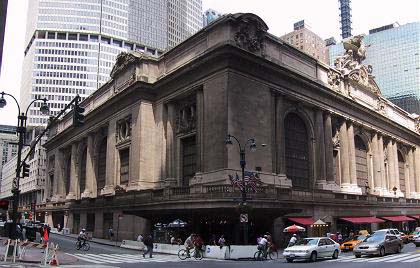
“It is critical to the successful integration of the site with the rest of Lower Manhattan that Dey and Cortland Streets be extended as real streets between Church and Greenwich. These streets must be designed to accommodate both vehicular and pedestrian use. The public realm in New York is primarily composed of streets and sidewalks. As such, Dey and Cortlandt provide key opportunities to expand the amount of open space and accessibility into the site. Furthermore, these streets will ensure that the typical block size along Church Street remains the same as the blocks to the north and south. In New York, with few exceptions, larger block sizes…are provided only for our most significant public buildings such as Grand Central Station” .
But we clearly understood Von Engel’s remarks when he alluded to the support of the project by his boss’s boss. It’s unfortunate that this support is clouding a true discussion of the real urban design issues at stake.
posted by Jonathan at 9:27 PM
![]()
![]()


7 Comments:
Also, I believe that a public street can be demapped even if it remains a working street. Thus, in addition to the elimination of public streets, the Atlantic Yards Project may end up, within its border, with private streets and sidewalks - a huge gated community that presumably could limit who enters or passes through, and when.
I believe that City Planning demapped Red Hook Lane in downtown Brooklyn last year, as well as the portions of N. 9th, N. 10th, N. 11th, and N. 12th streets in Williamsburg in order to have a contiguous waterfront park.
Streets can be demapped for Security Reasons by the NYPD. Furthermore the police do not have to declare why such sreets are being demapped - or closed - as the reasons themselves might reveal too much. Indeed the police will not - for that same reason - even indicate the overall policy criteria for determining why any street would be demapped or permanently closed. This means that the mayor, alone among elected officials, provides oversight. By this logic no one else needs be concerned that the criteria are both correct and complete, and if correct and complete that they are both correctly & completely applied in any particular instance.
An example is in order, though i'm not sure where the process is at this point: on October 6, 2005, the Police Dept. held public hearing on closing several streets within FCR"s Metro Tech campus. what's happening in one FCR development can easily happen in another.
So for a moment consider if some security critical tenant moved into one of the taller towers by the arena... say some portion of the the UN.... and the NYPD needs to close down 6th Avenue for the duration, or even, for some (good) reason, demap it altogether. Suddenly there's a whole new Traffic Flow to consider. Will the EIS cover this.
The Police Department has indicated that it has performed a security study of the Ratner project. The problem is that if this study remains under wraps, then the ESDC's EIS study will not be looking at a real world environment, but one that will be skewed to move the Ratner development forward.
And, as with the Metro Tech street demapping criteria, we are all left having to accept what we are being told on faith. That everything is done in our interests & for our safety and benefit... that oversight is not an issue... or having the benefit of colllective intelligience. Don't ever forget it was Guilianni who decided to locate the city's Emergency Response Center at the World Trade Towers against quite precient council.
alan rosner
It is important, for a few important reasons, to pin down ESDC on the status -- public/private -- of the streets and sidewalks within the legal boundary (as yet unpsecified) of the Atlantic Yards Project.
i think that this is an elitist argument of people who are resduced to such things because they cant intelligently discuss the project on its merits.
I don't think any of the above mentioned comments dismiss the potential (or merits) of this project. These posts are presenting real concerns that if not addressed will result in a final build-out that is less than adequate.
However, I do feel uneasy about criticizing "demapping planning" as another means to finding fault in this project. Demapping as a planning strategy is NOT always bad. In fact, I am involved with demapping some realized and unrealized "mapped streets" in New York City that were created during the "Robert Moses Highway / Street Fever" that will actually ensure home owners that unnecessary streets won't cut through their properties one day...
I also disagree with this Post's interpretation of the city's "policy" toward depmapping. The policy that Jonathan quotes, "agree to demap streets only if doing so supports sound urban design principles" is incredibly subjective and is NOT a policy; it is a principle. My guess is we all have a different idea of what "sound urban design principles" means and we may all be right...
The issue is not demapping. The issue is measuring the benefits of keeping the existing streets vs. closure. Which alternatives (closing the streets or keeping them "open") will best attribute to the highest quality of life for the largest number of people throughout all hours of the day, night and year. And we would want to measure this quantitatively and qualitatively.
IF this were a blighted area today (I realize this may have been a very different place even 10 years ago), one could argue that the streets are NOT functioning and do NOT contribute to a higher quality of life for pedestrians and homeowners. However, this is NOT a blighted area but a thriving slice of Brooklyn that is experiencing a dynamic transformation (on its own mind you and without the "help" of FCR and his cronies) as the crossroads between different people and uses.
The irony, is that the City and NYCDOT are rather critical of demapping streets. During a recent presentation for a street closure to Amanda B. it was recommended that we find another way to meet our goals without closing the street. She commented that the city does not like to close streets unless community and borough support it...
Where's her voice now?!?!?
Streets can be demapped without closing them. They simply become private streets. Where is the public benefit to that? ESDC will not say (I have asked them) whether the remaining, functioning streets will be demapped.
Post a Comment
<< Home