the design of the first atlantic center indeed sucks, as the basic design principle was "how can we take black folks' money and then convince them to leave quickly."
just something to consider about the first photograph, though, loading docks are entirely necessary in most urban development. without them, it would make the businesses located there really inefficient.
the alternative is double-parking or very expensive underground loading docks.
note the side of Macy's on 35th street. it's almost all loading docks, but it's not all that awkward.
having said that, they did lose an opportunity to do something interesting on this side of Atlantic Terminal, as there is a lot of pedestrian traffic along this corridor.
And you didn't even include a picture of the Fourth Avenue side of Ratner's PC Richards store. Thanks for providing the public realm with loading docks, cinder block walls, and blank windows. You guys sure do love Brooklyn.
My favorite thing to note is the way that Ratner started festooning his buildings with flags and banners a couple of years ago as if that would make up for the butt-ugly cheap disrespectfulness of them.
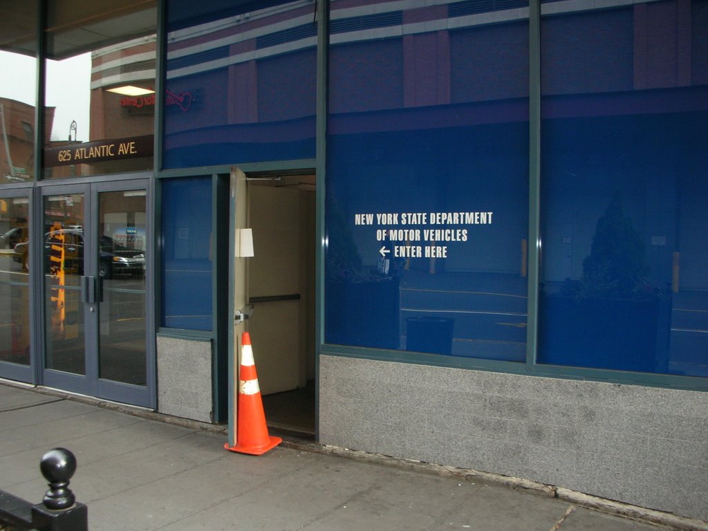
You left out another important category: subsidies for the Atlantic Center Mall and the subsequent bailout when DMV and ESDC took empty retail space. Isn't retail space supposed to be open weekends and evenings? Isn't that why taxpayers subsidized that mall?
...there's also his ugly buildings on Pacific Street, between Flatbush and 4th Avenues. After years of fighting for a more livable neighborhood, creating a community garden, fighting off crime and prostitution, the hard work of the block residents was awarded with the butt end of the PC Richards and Modells buildings. Stark temporary "tax-payer" buildings with no outdoor lighting creating a desolate, dangerous corridor for the neighborhood. Piggy-backing on the arena project, the state would condemn Ratner's own property, give it back to him free of any city zoning restrictions, and allow him to build a massive 60 story tower on this low-rise residential block.
This is a perfect example of what happens when the city gives away streets to private developers. The picture is of Fort Greene Place between Atlantic and Hanson which is now a demapped, private street. This street is a perfect example of the lack of foresight, lack of integration with the surrounding fabric, and extremely poor planning and management of pedestrian and vehicular traffic. Besides turning it's back to Fort Greene with ugly blank walls on two sides, pedestrian visitors to the Atlantic Center Mall/DMV coming from the Fort Greene side are subjected to an extremely dangerous obstacle course with truck loading docks and a parking garage entrance on both sides of the street. In addition, two of the pedestrian "sidewalks" are missing curb cuts at the loading docks, forcing handicapped persons to the middle of the street. NYPD officers arriving to testify at DMV hearings at Atlantic Center park their vehicles at every illegal spot in the area, including hydrants, crosswalks, loading docks, and even on one way streets going the wrong way. The traffic congestion caused by livery and gypsy cabs hustling shoppers; vehicles loading their shopping on the street; trucks maneuvering into extremely tight loading docks; and vehicles making U-turns on Fort Greene Place; is unbearable most of the time. Even something as elementary as proper storm drainage is neglected, as there is a huge puddle of water at the North West corner of Fort Greene Place and Atlantic Avenue every time it rains, due to the lack of a storm sewer inlet at that location. Pedestrians crossing the street at that corner are subject to being splashed by vehicles. If this is the way a public street turned over to FCRC has turned out, what are we to expect from the Atlantic Yards Plan? To add insult to injury, FCRC plans to use the air rights of Fort Greene place, a street that was "given" to them at no cost with new taxpayer-financed infrastructure in place, to build an additional 1.5 million square feet of mixed use space on top of the Atlantic Center mall (MOU # 2), and without being subject to an environmental impact study!
Yes! But we have a long way to go educating the public about these things. This is part of the point I made with my Atlantic Yards map. Another great example of this is on Elliot Street where Ratner just completely ignored the fact that he had residential neighbors and built a sheer wall of brick killing that block. That Mall is a disaster at integrating into the neighborhood. This is why there must be community review at all stages of these projects, not the just to review the scale and affordability but to also review the dumb ass designs these barrons come up with.
How much did Ratner pay for privatizing this block? What was the process? Does anyone have an answer to these questions?
It irks me to no end that we as citizens have lost our public space for THIS.
Think of how beautiful this block could be. If you like malls, it could be a great shopping street. And if you like loading docks, why not use the unused eastern side of the Atlantic Center? It is further from the Altantic Terminal, but it could have opened this street up to more profitable uses.
wow. your site is very cool. beautiful to look out.
I have a question: do you have any idea what the stats are as to how many live per average brooklyn city block? I know we are different bc of all the brownstones. someone told me about a thousand. this seems high. or is it too low? i am sure there has to be a stat somewhere, and perhaps an architect would know it!


9 Comments:
All of the above
the design of the first atlantic center indeed sucks, as the basic design principle was "how can we take black folks' money and then convince them to leave quickly."
just something to consider about the first photograph, though, loading docks are entirely necessary in most urban development. without them, it would make the businesses located there really inefficient.
the alternative is double-parking or very expensive underground loading docks.
note the side of Macy's on 35th street. it's almost all loading docks, but it's not all that awkward.
having said that, they did lose an opportunity to do something interesting on this side of Atlantic Terminal, as there is a lot of pedestrian traffic along this corridor.
And you didn't even include a picture of the Fourth Avenue side of Ratner's PC Richards store. Thanks for providing the public realm with loading docks, cinder block walls, and blank windows. You guys sure do love Brooklyn.
My favorite thing to note is the way that Ratner started festooning his buildings with flags and banners a couple of years ago as if that would make up for the butt-ugly cheap disrespectfulness of them.
You left out another important category: subsidies for the Atlantic Center Mall and the subsequent bailout when DMV and ESDC took empty retail space. Isn't retail space supposed to be open weekends and evenings? Isn't that why taxpayers subsidized that mall?
...there's also his ugly buildings on Pacific Street, between Flatbush and 4th Avenues. After years of fighting for a more livable neighborhood, creating a community garden, fighting off crime and prostitution, the hard work of the block residents was awarded with the butt end of the PC Richards and Modells buildings. Stark temporary "tax-payer" buildings with no outdoor lighting creating a desolate, dangerous corridor for the neighborhood. Piggy-backing on the arena project, the state would condemn Ratner's own property, give it back to him free of any city zoning restrictions, and allow him to build a massive 60 story tower on this low-rise residential block.
Jon Crow, member, Brooklyn Bear's Garden
This is a perfect example of what happens when the city gives away streets to private developers. The picture is of Fort Greene Place between Atlantic and Hanson which is now a demapped, private street. This street is a perfect example of the lack of foresight, lack of integration with the surrounding fabric, and extremely poor planning and management of pedestrian and vehicular traffic. Besides turning it's back to Fort Greene with ugly blank walls on two sides, pedestrian visitors to the Atlantic Center Mall/DMV coming from the Fort Greene side are subjected to an extremely dangerous obstacle course with truck loading docks and a parking garage entrance on both sides of the street. In addition, two of the pedestrian "sidewalks" are missing curb cuts at the loading docks, forcing handicapped persons to the middle of the street. NYPD officers arriving to testify at DMV hearings at Atlantic Center park their vehicles at every illegal spot in the area, including hydrants, crosswalks, loading docks, and even on one way streets going the wrong way. The traffic congestion caused by livery and gypsy cabs hustling shoppers; vehicles loading their shopping on the street; trucks maneuvering into extremely tight loading docks; and vehicles making U-turns on Fort Greene Place; is unbearable most of the time. Even something as elementary as proper storm drainage is neglected, as there is a huge puddle of water at the North West corner of Fort Greene Place and Atlantic Avenue every time it rains, due to the lack of a storm sewer inlet at that location. Pedestrians crossing the street at that corner are subject to being splashed by vehicles. If this is the way a public street turned over to FCRC has turned out, what are we to expect from the Atlantic Yards Plan? To add insult to injury, FCRC plans to use the air rights of Fort Greene place, a street that was "given" to them at no cost with new taxpayer-financed infrastructure in place, to build an additional 1.5 million square feet of mixed use space on top of the Atlantic Center mall (MOU # 2), and without being subject to an environmental impact study!
Yes! But we have a long way to go educating the public about these things. This is part of the point I made with my Atlantic Yards map. Another great example of this is on Elliot Street where Ratner just completely ignored the fact that he had residential neighbors and built a sheer wall of brick killing that block. That Mall is a disaster at integrating into the neighborhood. This is why there must be community review at all stages of these projects, not the just to review the scale and affordability but to also review the dumb ass designs these barrons come up with.
How much did Ratner pay for privatizing this block? What was the process? Does anyone have an answer to these questions?
It irks me to no end that we as citizens have lost our public space for THIS.
Think of how beautiful this block could be. If you like malls, it could be a great shopping street. And if you like loading docks, why not use the unused eastern side of the Atlantic Center? It is further from the Altantic Terminal, but it could have opened this street up to more profitable uses.
wow. your site is very cool. beautiful to look out.
I have a question: do you have any idea what the stats are as to how many live per average brooklyn city block? I know we are different bc of all the brownstones. someone told me about a thousand. this seems high. or is it too low? i am sure there has to be a stat somewhere, and perhaps an architect would know it!
thanks.
Post a Comment
<< Home