An Amazing Technical Feat of Illusion
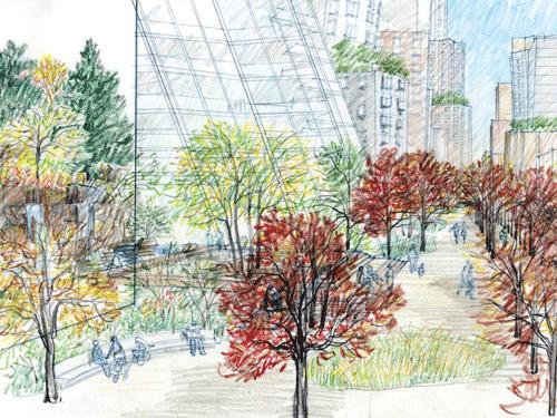 Image from FCRCs Web Site
The dioramas at the Museum of Natural History, “amazing technical feats of illusion” are created by seamlessly blending 3D modeling with 2D scenography. In a similar manner, a dissolving slide show of recent renderings for the project blends a depiction of real space with the wall of a building. By glossing over the inconvenient reality of sight lines, and in an attempt to make the landscaped areas seem larger than they could really be, a natural park-like setting replete with waterfalls and forest is superimposed on the base of a proposed tower. These are not two different images, it is one image containing contradictory ideas for the space. A revealing view of conflicting goals: the same space can’t be occupied by both a building and a landscape.
Much has been written about the unsolicited promotional flyer that the developer distributed in the mail this week. It contains dozens of images of attractive people, and nice photographs of our existing neighborhood, but only two images of the project: a landscape plan and a rendering of the pond. Why show a row of brownstones when the project is a mass of highrises taller and wider than the Williamsburgh Savings Bank? Like the rendering, the brochure is a sop to the neighborhood, masking the true intentions of the project. For those unfamiliar with the design intent, it would be impossible to understand the proposed scale of the development from the information provided. That large green area rendered in plan? Why not come clean with the fact that it would actually be well over 100 feet above the street, on the roof of the basketball arena?
The flyer does begin to flesh out the program for the arena: in addition to basketball, it will host “community events – including school sports, high school and college graduations – and family events such as concerts and circuses “. While we’re actually not looking forward to a giant Madison Square Gardens style venue for concerts in our backyard, not to be accused of NIMBYism we won’t argue with the dire need for more venues for circuses at this intersection. But this isn’t the full program: why no mention of the “extreme sports” events that were presented to City Council by the developer last year? And about space for school graduation ceremonies: as veterans of the public school system will attest, the challenge for schools is really not where graduations will be held. It’s in preparation for graduations. Wouldn’t a real community masterplan, “thoughtful and visionary – for the Brooklyn we know and love” with a budget of 3.5 billion dollars, be investing in our kids by including a new school?
We have posted previously about how limited the area of new open space at-grade really is, given the proposed density. The space assumed by taking an existing street and calling it “the project’s open space” does not create more space. It merely transfers the ownership of existing public space to private control. And ultimately, this is not better space than a street. A real street provides real connections to the surrounding area and, by allowing through-circulation integrated with the circulation patterns of the city, ties the life of new buildings to the surrounding communities. By closing the street, the new development isolates itself, both physically and in spirit, from the surrounding areas. Saying it’s connected does not make it connect. An image of a great space does not make a space great. We’re not taken with this illusion, and a glossy brochure showing happy people and existing brownstones is just not enough to get Brooklyn singing Kumbaya around this project.
posted by Jonathan at 10:10 PM
![]()
![]()

3 Comments:
another great post. i keep sending links out to people, hoping to spread the word.
and the limited open space will be private -- the roof off limits to the public, the minimal ground level open space likely to be private property, which, though open to the public under whatever conditions, is not the same as a public space.
Ratner has been mute on the matter of legal boundaries for obvious reasons. This will be a giant gated community, created by eminent domain.
We have to wait for issuance of the General Project Plan to learn the public/private boundaries.
In contrast to the paltry open space, the project will create private roads, parking, and other paved automobile surfaces within the Project, equivalent to 16 miles of roadway, an environmental and traffic disaster.
I think the best in all this is how so many statements in that brochure has been refuted. I think I saw an article in one of the Brooklyn newspapers how the woman modeling in a red dress in the park was absolutely livid about being used in this manner. She had not been told the images would be used for this purpose and so...
With hopes the DEIS will come out objectively...
/Lindus
Post a Comment
<< Home