Street Logic
Earlier posts discussed how increasing the site area, by taking the streets, enabled the project to game the system. This post illustrates how the overall project claims open space and Floor Area Ratios (FAR) in a manner inconsistent with the intent of these measures in New York.
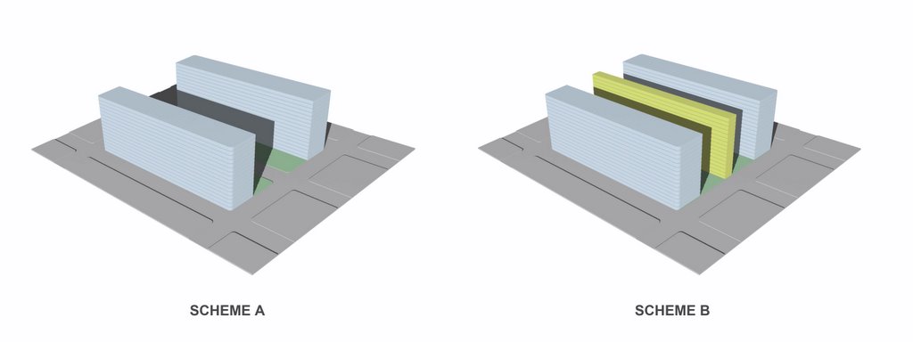
Compare two hypothetical projects, we’ll call them Scheme A and Scheme B, both built on two-block sites. The diagrams above show two different methods of calculating the open space and the FAR; the actual configuration of the massing on the site is immaterial here. Scheme A does not take the street between the blocks, Scheme B does. Scheme A builds on half of both blocks, leaving open 2-half blocks, or space equivalent to one city block. Scheme B builds on half of both blocks and also on half of the street, leaving the same space open on the blocks as Scheme A. But since Scheme B counts half the street as open space as well, even though it has a larger built foot-print than Scheme A, it claims more open space. And we’ve lost our street.
With similar Orwellian logic, Scheme B claims the same Floor Area Ratio as Scheme A, even though it builds more. The Floor Area Ratio is a measure of building density, useful in urban planning discussions and policy decision making. It is calculated by dividing the total area of floors in a project by the total site area. But like all measures, it is only significant as a standard when used to compare projects in similar contexts. In Brooklyn, the FAR measures density relative to the existing pattern of streets and blocks. If Scheme A builds to an FAR of 6 (ie. the total floor area is six times the site area), Scheme B claims the same “FAR” while building more floor area, due to the larger site claimed.
And another thing: other than this calculated slight of hand, there is no good reason to take Pacific Street between Carlton and Vanderbilt. In a recent interview found today on Norman Oder’s TimesRatnerReport, Gehry expressed his anxiety about the planning so far: “…how do you make buildings that fit, how do you make a new skyline, how do you develop a scale at the ground level, how do you create the opportunities…” One place to start could be by respecting the existing streets. The street is not some other architect’s mistake, waiting for Forest City Ratner to correct; it is the deep structure of urban form. This is not about replicating 19th Century architecture, but about learning from the large scaled mistakes of 20th Century interventions.
posted by Jonathan at 2:40 PM
![]()
![]()


4 Comments:
Right on the money! At the AIA meeting with Frank Gehry regarding Atlantic Yards, Jim Stuckey of FCRC made a big deal of how the FAR at Atlantic Yards is less than that allowed by the Downtown Brooklyn Zoning. I wish this information was available to us then to put him back in his place. We need to drive this point across to the various politicians, media and community organizations. It is a very important point.
man, this is really great stuff but very technical. i think we need to blow up that visual you made and figure out a way to explain the entire story on a single image graphic with minimal text. it's got to be made super simple for public consumption.
I want to reinforce and echo anonymous (11:40pm)and state that this is important information and that the image should be bigger and text made more simple.
Another thought...
A few of your entries mention the importance of THE STREET as both public open space and as "the deep structure of urban form." As New Yorkers we understand intrinsically why the street is important; but, I wonder if others (for example a Californian architect) appreciate this value as much as we do. I think you should reinforce these ideas in a blog devoted to the street. I think you can do this in a way that is consistent with your "straight forward/stating just the facts" approach.
I look forward to your blog every day. Keep it up!
Just for comparison, on your typical 200x1000 block that houses 500 to 600 families, the allocatable adjoining street, sidewalk and stoop setback represent about 3.25 acres and the semi-private stoops another .75. The private space, the back gardens, represent an additional 2 acres.
Low rise high density works. Highrise, high density in a super block may work if for small families and very tightly managed like Stuyvesant Town or Peter Cooper Village. I don't want to live there or particularly want it nearby, but i think that rather than argue Gowanus Houses for effect, however satisfying, we should look at the lessons learned from comparable projects. It would be a stronger argument.
Post a Comment
<< Home