Saturday, January 28, 2006

Real FAR


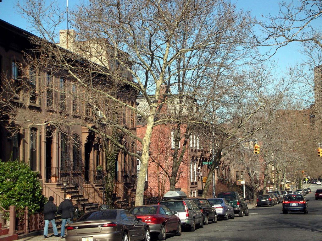
At the public meeting on Thursday, we discussed this Floor Area Ratio (FAR) thing again. The FAR is the ratio of built area to site area. It’s important because it’s the accepted measure of building density on a site in the city. While open space, building setbacks, and height limitations constrain building configurations, FAR is the way we understand how much building can be on the site. And depending on the use of the building (residential, commercial, etc.), FAR also becomes a pretty good indication of the number of people that will be there, and their impact on traffic, services, utilities, and so on.

The public assembly use of the arena makes its impact not really measurable by an FAR, since the impact of crowds is out of proportion to the typical use of built areas. However, because the proposed project includes an arena on the site, the air rights for density will be transferred to the rest of the site, making the non-arena components much denser than they would be without the arena. This in itself is a reason to limit the averaged FAR on the site, as a whole, to something reasonable, since the non-arena areas will be much denser than the average.

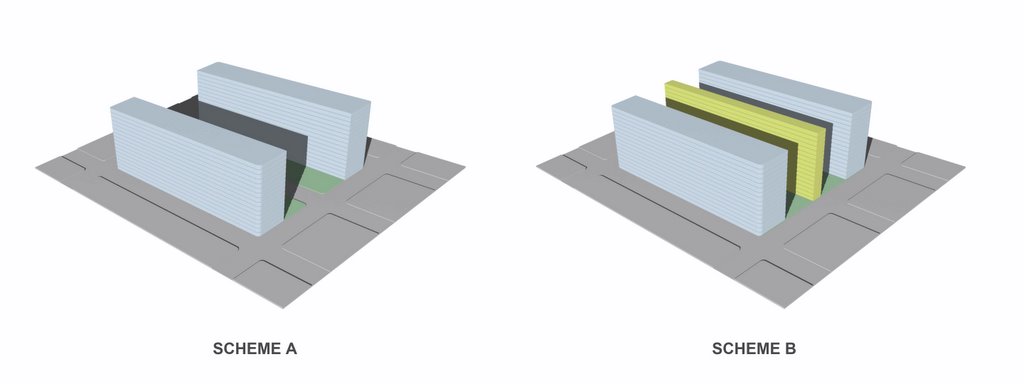
What is an appropriate FAR for the site? We’ve discussed in previous posts that the ratio of built area to site area is relative to the pattern of streets and blocks. An FAR figure for a superblock is not comparable to an FAR for a typical Brooklyn block, because a superblock uses the street for part of the site area. The chart below compares the two blocks at the eastern end of the site - each nominally 200’ x 1000’, on either side of a 70’ (property line to property line) street - with a superblock occupying the same total area. Dimensions would need to be verified for the entire site to make a definitive comparison.


Built Area (sf) ....Superblock FAR ......Brooklyn-block FAR
470,000 ................1.00 ........................1.17
940,000 ................2.00 ........................2.35
1,410,000 .............3.00 .........................3.52
1,880,000 .............4.00 ........................4.70
2,350,000 .............5.00 ........................5.87
2,820,000 .............6.00 ........................7.05


So when we hear that the proposed FAR on the site with demapped streets will be say, 6.00, we will understand that to be equivalent to a Brooklyn-block 7.05, which is significantly more dense. And conversely, if we can understand a density equivalent to an existing-street-pattern FAR of 6, we should be looking for a superblock calculation of about 5. We’re not developers, it’s not a position to negotiate from, nor will we be asked to negotiate this position, it’s just the facts. The Extell proposal proves that a 6.0 FAR with streets retained is economically feasible.

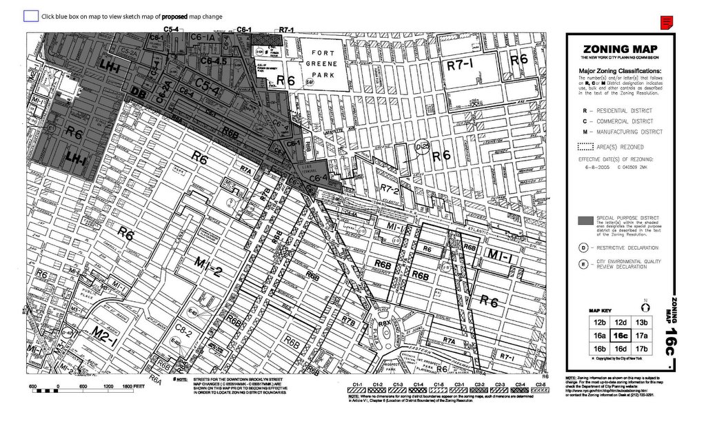
Why a real 6.0? This is substantially more dense than current zoning. The current Zoning Map shows three different zones on the site: R6B (FAR = 2.0), for the North side of Dean between 5th and Carlton (and most of Prospect Heights), R7A (FAR = 4.0) for the Flatbush and Vanderbilt corridors, and M1-1 (FAR = 1.0) for the remainder of the site. But downtown Brooklyn has recently been rezoned much denser, with some limited areas at 10 and even 12 FAR, surrounded by 6.02 FAR areas.

For the Atlantic Yards site, 6.02 appears to be the intent of the Downtown Brooklyn Development Plan. On their web site, City Planning explains the Downtown Plan: “Rezone Southern Flatbush Avenue Area to C6-2…Increasing the residential FAR from 3.44 to 6.02 would encourage new residential development….and support development surrounding Atlantic Terminal”. While the Atlantic Yards site is not in Downtown Brooklyn, the Downtown Brooklyn Development Plan was developed with an understanding of the surrounding neighborhoods. The Downtown Brooklyn Development Plan went through the ULURP process, was recommended for approval by the Borough President and Community Board 2, was approved by the City Planning Commmission, and was adopted by City Council on June 28, 2004 (with a modification establishing building height limits). We have to believe these people did their homework.

Wednesday, January 25, 2006

Posting Comments


Sorry Readers, I haven't been seeing many of your comments - a problem of learning on the project. I think I've posted them all now.

Sunday, January 22, 2006

The Role of the Architect II


Looking towards the site, north on Carlton Avenue from Bergen Street


The previous post discussed the advantages of having a star architect working on the project. But there are also disadvantages. While he is more likely to be successful in influencing the developer-provided project direction, he may also be less likely to listen to the ideas, input, and concerns of others. An architect with major commissions around the world may not have the time or interest to learn much about the unique site conditions of each one, preferring instead to explore common themes of interest across all of them. And while our site can benefit from lessons learned in other locations, that benefit may come at the expense of the genius loci here.

Take, for example, Gehry’s
claim that “there is a constituency of people that live there who fantasize this Brooklyn as brownstones and Court Street and Carroll Gardens and all that, which isn’t on this site." A troubling comment - people who live here are fantasizing about the nature of their neighborhood - from someone who doesn’t live nearby. Court Street and Carroll Gardens? What’s that about? Is this his idea, or someone else’s? Several of the buildings on the site, slated for early demolition, are in fact indistinguishable from buildings on Court Street and Carroll Gardens and all that. It would not be difficult to take a stroll around and see that the site is surrounded by areas that are not only contiguous brownstone neighborhoods - similar to Court Street and Carroll Gardens and all that - but more so. See for yourself. And at the same time it’s more diverse and needs to be connected at the site, not separated. We need our streets. We don’t need private “public” open space that requires a private security force to protect. This is not Grand Avenue in Los Angeles.

Take also Mr. Gehry’s
claim that citizens’ groups “should back off when somebody knows what they’re doing”. What does that mean? If you “know" what you’re doing, you have nothing to learn, so you don’t have to listen? I know he’s said all the right things as well: reach out to the community, wanting to meet, wanting to connect, etc. We all could have said some things better. But in the end the architect has a unique role: it’s not what you say, it’s what you do that counts.

Monday, January 16, 2006

The Role of the Architect


Let’s tackle the difficult question: what do we think about Frank Gehry doing this project in our neighborhood? Our typical answer: Gehry is known to be a great architect, but there are real problems with this project. It’s too big, it’s too dense, the crowds will be unmanageable, people driving will take our spaces first, traffic is going to be even worse, the megablocks will detract from our streets, not enough public space, and it’s all private not public, why can’t we have a great pedestrian environment? We understand that the density is driven by the arena – the arena loses money so the real estate has to make it back. (Where’s a big media company when we need it?) Marty Markowitz wanted the team, and the deal made sense to the developers if they could make their profit on the real estate. How to sell it? Let’s get Frank! So here we are.

How much responsibility does the architect bear for the problems? Has Gehry’s predilection for hard street fronts determined the closing of streets? What can we say about his association with a plan that everyone knows is far too dense for the site?

Let’s start by acknowledging that an architect’s mission is different from that of a developer. People say different things about their intentions, but let’s be clear about the players’ respective roles. Architects want to make successful architecture; development teams require their projects to be profitable. And while it may be a good business plan for developers to try to gain popular approval for their projects, a good business plan is only a means to an end: the financial success of the project. In the pairing of developer and architect, let’s also keep in mind the primary relationship: the architect works for the developer, which despite the rhetoric is not a partnership. For better or worse, architects have virtually no say in the program, which includes total built area, area for different components, site limits, amount of parking, etc. These are critical items for determining the financial success of the project; in some projects an architect can weigh in, but they are always finally determined by the developer.

Given this relationship, it does help that Gehry is on the job. He will be more able to push for influencing the program and it’s disposition on the site than anyone else could in that role. From the public’s perspective there is a real advantage to having a star architect working on a project; a renowned architect has more clout to influence the program. Well-known architects can pick and choose commissions, and if a client proposes a direction that is not of interest, they can always decline to participate. Lesser known architects work at the behest of the client, knowing that satisfied clients will give them more work. A star architect plays to a different audience: his place in history. It behooves him to do the right thing, or to not do it at all.

Wednesday, January 11, 2006

Parking


Anonymous responded to a previous post: “Parking for 4000 cars is the same as about 19 miles of roadway”. We're not sure if this was in support or in opposition to providing venue parking, which we oppose, but let’s consider this a bit more.

A typical parking spot is roughly 20’ long, so 4,000 spots, lined up end to end, would be 80,000 feet long. Since one mile is 5,280 feet, 4,000 spots is, in fact, equivalent to over 15 miles of cars, lined up end to end, without cross-streets or gaps. If these cars were all to arrive at the same time, or to leave at the same time, this does mean a line of cars stretching from the site to the Goethals Bridge , or to the Meadowlands in New Jersey, assuming no gaps and no other traffic in this single lane.

Why New Jersey? Neil Best, writing in
NYNewsday, documents the efforts of Brett Yormark to develop the New Jersey fan base for the Nets, with the hope that they will stick with the team after it makes the move to Brooklyn. In the report on the estimated fiscal impact of the project, commissioned by the developer and prepared by Andrew Zimbalist, it is assumed that 30 percent (2,681) of current fans of the Nets who reside in New Jersey will attend games in Brooklyn. In addition, 5,802 current fans from outside NJ will attend games in Brooklyn. However, in a comprehensive analysis of this report, Jung Kim and Gustav Peebles find the projection of outside support for a Brooklyn team severely flawed and overly optimistic. The arena’s economic model depends on New Jersey fans coming to Brooklyn. But if New Jersey fans come to Brooklyn, they will drive. Are we providing venue parking to validate a flawed economic model?

In a recent
article by Nicholas Confessore in the Times, FCR claims to recognize that traffic is a “challenge”. They hope to rely “largely on remote parking for sports events”. In this article, the developer wants us to believe that since basketball games start at 7:30, the traffic generated by the games will not conflict with existing traffic patterns. But this view of rush hour is contradicted by their own consultant “Gridlock Sam” in the Daily News this week, where he ominously warns: “Friday's evening rush hour may be affected by the Nets' 7:30 p.m. matchup against Orlando”.

And ultimately, the developer’s claim in the Times that “traffic has to work for us, too” because the success of the residential units will be “directly tied to the quality of life” rings hollow. The fact is, the most congested areas of the city are not necessarily lacking for tenants. If there is any correlation between rental prices and traffic, it would just as likely run the other way, ie. the more traffic, the higher the rental price. Economically “successful” projects are not necessarily successful quality of life models, witness Metrotech and the Atlantic Center mall. This is something difficult for developers to be responsive to: quality of life is not just an economic measure.

Saturday, January 07, 2006

Learning From Los Angeles


Tom McGeveran wrote this week, in The New York Observer's The Real Estate, that this blog is more sober than others on Atlantic Yards. Thanks, I think. But that doesn’t mean we can’t reference some less polite sources….

In 1990, Mike Davis (aka “The Friedrich Engels of Los Angeles”) observed of the new developments in downtown L.A.:


The American city, as many critics have recognized, is being systematically turned inside out – or, rather, outside in. The valorized spaces of the new megastructures and supermalls are concentrated in the center, street frontage is denuded, public activity is sorted into strictly functional compartments, and circulation is internalized in corridors under the gaze of private police” ….“De facto disinvestment in traditional public space and recreation has supported the shift of fiscal resources to corporate-defined redevelopment priorities. A pliant city government – in this case ironically professing to represent a bi-racial coalition of liberal whites and Blacks – has collaborated in the massive privatization of public space …. Yet most current, giddy discussions of the “postmodern” scene in Los Angeles neglect entirely these overbearing aspects of counter-urbanizations and counter-insurgency. A triumphal gloss – “urban renaissance,” “city of the future,” and so on – is laid over the brutalization of inner-city neighborhoods ….even as the walls have come down in Eastern Europe, they are being erected all over Los Angeles.” (From
City of Quartz, p. 225)

So, 15 years later, after a period in which Prospect Heights has witnessed its own renaissance, how has the "urban renaissance" of downtown Los Angeles progressed? This week, John Pomfret
wrote in the Washington Post about downtown Los Angeles:

More pets than children live downtown, and no schools serve the area. Because much of downtown was rebuilt at the height of the automobile age, at some intersections it’s impossible to walk across the street. At night, the area is desolate and its nightlife is more like a dusk life. The kitchen at the swankiest restaurant, Pinot, closes at 9. It is impossible to hail a cab because the police department refuses to allow random stops, but even if it did, most Los Angeles cabbies would not take short fares. Local redevelopment boards have hired their own security services and trash collection services because city services are stretched too thin.”

What are the lessons that Los Angeles has to offer us about urbanism? Fuggedaboutit!

Monday, January 02, 2006

Street Logic


Earlier posts discussed how increasing the site area, by taking the streets, enabled the project to game the system. This post illustrates how the overall project claims open space and Floor Area Ratios (FAR) in a manner inconsistent with the intent of these measures in New York.

Compare two hypothetical projects, we’ll call them Scheme A and Scheme B, both built on two-block sites. The diagrams above show two different methods of calculating the open space and the FAR; the actual configuration of the massing on the site is immaterial here. Scheme A does not take the street between the blocks, Scheme B does. Scheme A builds on half of both blocks, leaving open 2-half blocks, or space equivalent to one city block. Scheme B builds on half of both blocks and also on half of the street, leaving the same space open on the blocks as Scheme A. But since Scheme B counts half the street as open space as well, even though it has a larger built foot-print than Scheme A, it claims more open space. And we’ve lost our street.

With similar Orwellian logic, Scheme B claims the same Floor Area Ratio as Scheme A, even though it builds more. The Floor Area Ratio is a measure of building density, useful in urban planning discussions and policy decision making. It is calculated by dividing the total area of floors in a project by the total site area. But like all measures, it is only significant as a standard when used to compare projects in similar contexts. In Brooklyn, the FAR measures density relative to the existing pattern of streets and blocks. If Scheme A builds to an FAR of 6 (ie. the total floor area is six times the site area), Scheme B claims the same “FAR” while building more floor area, due to the larger site claimed.

And another thing: other than this calculated slight of hand, there is no good reason to take Pacific Street between Carlton and Vanderbilt. In a recent interview found today on Norman Oder’s TimesRatnerReport, Gehry expressed his anxiety about the planning so far: “…how do you make buildings that fit, how do you make a new skyline, how do you develop a scale at the ground level, how do you create the opportunities…” One place to start could be by respecting the existing streets. The street is not some other architect’s mistake, waiting for Forest City Ratner to correct; it is the deep structure of urban form. This is not about replicating 19th Century architecture, but about learning from the large scaled mistakes of 20th Century interventions.