Ideas About The Proposed Atlantic Yards Project
in Prospect Heights
Thursday, December 29, 2005
Demolition II
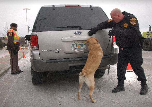
Open Windows: another building on the site in the process of becoming a threat to public safety.
An earlier post suggested that some of the buildings that will soon be demolished by Forest City Ratner may in fact be in relatively good repair. While some of them look fine from the outside, apparently we have to accept the developers’ statement - that their engineering report requires that the buildings be demolished immediately since they pose a threat to public safety - since no independent engineer is permitted to see the interiors.
Severe structural damage is said to have been caused by recent water infiltration. This is relatively unusual in New York; there are several well-known buildings in all neighborhoods that have stood empty for decades, and have managed to maintain their structural integrity. Property owners know that severe structural damage caused by water infiltration is an indication of willful neglect. While due process, as required by the State’s Environmental Impact Statement process, mandates that no work be done on the project during the impact assessment phase, work required for public safety trumps due process. So the forces of nature have been enlisted to expedite work on the project and push along the project’s schedule. The fact that these buildings have been allowed to deteriorate to the point of requiring demolition is a matter of expediency for the developer.
So where is the public input process in all of this? Isn’t it conceivable that a possible mitigation action, coming out of the Environment Impact Statement process, could be to explore ways to integrate the project into the surrounding neighborhoods? Couldn’t one strategy to do this be to maintain some of the existing character and scale of the significant buildings on the site, and adaptively reuse them in the project? Causing the buildings on the site to be demolished limits the options available to the design team. What’s the point of public input if there are no options to the developers’ first plans?
The trouble with trying to imagine interior public space as circulation space without a street is that it is impossible for it to be successful.
If the interior of the block is not well used for circulation, these walkways become empty and dangerous places. It’s a model that was tried by the New York City Housing Authority in the 1960's, which now fences in the walkways (Above: Wyckoff Gardens).
On the other hand, if the project is “successful”, and the interior of the block is well used for circulation, these areas actively draw people off the surrounding streets, weakening the activity on them. This is the Metrotech model. For a retailing street, this demeans the viability of the surrounding retail establishments. For a residential street, it detracts from our connections to the wider communities, and diminishes our sense of security.
This anti-urban pattern is at odds with the vision we have of Brooklyn. We envision great pedestrian streets here, which tie together different communities and provide for the full range of circulation modes. While this vision can accommodate a range of scales of built form, the continuity of the street grid is an absolute necessity.
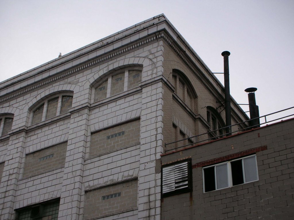
Forest City Ratner is planning to demolish six buildings, beginning this Tuesday: 620 and 622 Pacific Street, 461, 463 and 585 Dean Street, and 608-620 Atlantic Avenue (The Underberg Building). According to a report in the Times by Nicholas Confessore, there is some damage to the interiors, including, “tin-ceiling panels, drywall, even a broken-down piano”.
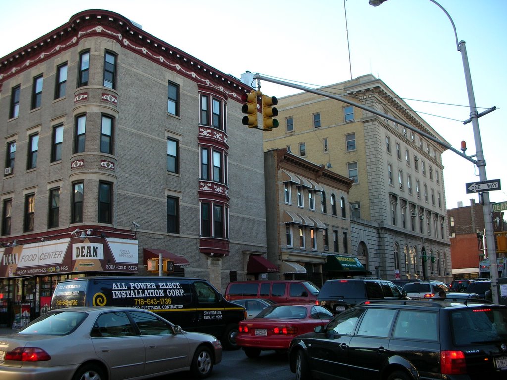
But from all appearances on the exterior many of these buildings are not in bad shape. 461 and 463 Dean Street, for example (above), are fine examples of period housing and contribute to the urban fabric. Is FCR grouping solid buildings with some damaged ones in order to expedite the clearing of the site and circumvent due process? They should be maintained in place while the Environmental Impact Statement process is underway.
In a previous post we discussed why the arena will not be able to provide parking under Blocks 1119 and 1127. Security experts agree that parking areas should no longer be located below sports and entertainment facilities, and that buffer areas should be provided for pedestrian-only circulation at sport venues (See link). In fact, according to a recent Sports Illustrated article, the NFL and MLB prohibit parked vehicles within 100 feet of stadiums for security reasons.
On this site, since all of Block 1121 and most of Block 1120 will continue to house the LIRR train yard just below grade, the only available area of any consequence for underground venue parking is the Phase II Block 1129. This block, at below-grade levels, is also the only site available for Phase II residential/office parking. Is it possible to excavate deep enough to provide both residential/office and venue parking below Block 1129? Depending on the elevation of rock, this could easily add a hundred million dollars to the construction budget, a very conservative estimate. More likely: look for parking garages to spring up further east on Atlantic Avenue.
There really are only two options: either move the arena to a different site, or invest in rapid transit and don’t provide associated venue parking. If Madison Square Gardens is the model, no directly associated venue parking is required. If a MLB stadium, or Continental Airlines Arena at the Meadowlands is the model, build the arena someplace else, where people can drive to it.
As an exercise, let’s work the numbers the other way. Assume that the project really could make a significant public open space. If that space were to occupy an area the size of a city block – say 200’ x 1,000’ – it would equal 200,000 sf, or 4.6 acres. At the city’s standard of 2.5 acres per 1,000 residents, this open space would support a population of 1,840. At an average of 2 people per unit, this equates to 920 residential units. By way of comparison, the current scope calls for 7,300 units.
An earlier post looked at the project's strategy of taking streets to "improve" the Floor Area Ratio. A similar point should be made relative to open space. For the planned residential development, active open space is critical, and Brooklyn currently has a shortage. Have you seen the AYSO schedules for the Parade Grounds on a spring or fall weekend?
The Draft Scope proposes 7 acres of “Publicly Accessible Open Space”. Sound good? One acre is 43,560 square feet. Seven acres is 304,920 square feet. But existing open space in the form of public streets and sidewalks would be taken by the project: Pacific between Carlton and Vanderbilt (approx.1000 ft.), Pacific between Sixth and Flatbush (approx. 700 ft), and Sixth Avenue between Flatbush and Atlantic (approx. 200 ft.), for a total street length of about 1,900 ft. If the width of a street - property line to property line - is approximately 70’, the total street area that would be demapped and delivered to the project is about 133,000 square feet: over 3 acres. So almost half of what the project is “providing” in open space is space that was already supposed to be open in perpetuity, according to the city plan.
The City’s CEQR Technical Manual provides guidance for open space requirements for projects. 1.5 acres of City Parkland per 1,000 residents is the median community district ratio, although the citywide average is 3.5 acres per 1,000 residents. While not a regulatory standard (unfortunately), “For planning purposes, the city seeks to attain a planning goal of 2.5 acres per 1,000 residents”. This 2.5 acres is relative to the city's existing pattern of streets and blocks, where the streets provide additional open space that is not counted in the ratio. If we didn't have streets, the requirement for open space would be much greater, so we can't count the street area when comparing the amount of open space required by a project to the city standard that assumes 70' wide streets every 200 feet. (In addition, “.15 acres of passive open space per 1,000 workers represents a reasonable amount of open space resources for that population”). (P.3D-13)
So let’s do the math. The project's scope calls for 7,300 residential units. 7,300 units at an average of 2 people (?) per unit is 14,600 residents. The requirement for 14.6 thousand people at 2.5 acres per thousand = 36.5 acres of open space, according to the city’s standard. But rather than the required 36.5 acres of open space, not even counting the requirements for the arena or the office space, the developer is proposing to add 4 acres, not counting our currently open streets. For the proposed scope of this project, that’s a 10% solution.
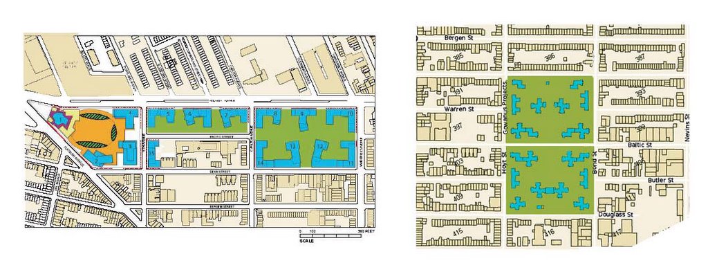
We know of several examples of breaking the grid to place towers in a park. Gowanus Housing comes to mind. Set in the middle of Brownstone Brooklyn, Warren Street and Butler Streets were discontinued in the name of progress and increased density, and a site plan was developed with paths and fountains. Irrespective of the architecture, does the relative scale and site configuration determine success or failure?
Ultimately, venue parking - as currently proposed - won’t happen. Perhaps it is in the plan as a negotiating item to be dropped later, in a show of compromise. Or is it possible that the developer really doesn’t yet understand that public parking under the arena can’t happen as proposed? The Freedom Tower in lower Manhattan was moved to be further away from the street. We’re checking back-packs at subway stations. Does anyone really believe, post 9-11, that we’ll allow unchecked passenger vehicles to drive under an arena filled with 20,000 fans at events carried live on national TV?
Could the vehicles be checked first? Proper checking takes time. Even a minor delay for arriving vehicles would result in total grid lock on the streets. Let’s drop the charade and talk about real options.
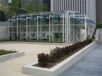
Wanting to distribute some good ideas, besides critiques of the bad. The Atlantic Yards site is ideally suited to be a significant bicycle hub. It’s located just off several bike paths, a close ride to Prospect Park, and near the Long Island Railroad and virtually all subway lines going into Manhattan. The project should provide for a bicycle concession to serve bike commuters and recreational bicyclists: lockers, showers, and bicycle rental and repair. A facility like this recently opened: the New Millennium Park Bicycle Station in Chicago.
The intersection of 6th Avenue and Dean Street, looking southeast. The 78th Police Precinct is on the right, the firehouse for Engine 219/Ladder 105 is just to the left. 6th Avenue is typically congested already. Arena venue parking and truck access are both proposed to be added immediately adjacent to this intersection, on the north side.
This comment on a previous post got me thinking: Your previous observation on the traffic implications of the proposed curb cuts should spark some sort of inquiry given the implications for the adjacent emergency services. Do you know whether it's specifically in the draft EIS?
Good question. Task 5 of the Draft Scope of Analysis for an Environmental Impact Statement (EIS) (Community Facilities and Services, P.20) states: “The ability of the fire department to provide fire protective services for a new project usually does not warrant a detailed assessment….Generally, a detailed assessment of fire protective services is included only if a proposed project would affect the physical operations of, or access to and from, a station house; and…. Generally, a detailed assessment of police protective services is included only if a proposed project would affect the physical operations of, or access to and from, a precinct house. Based on these thresholds and the proposed project program, detailed analyses will be conduced for public schools, libraries, health care facilities, and day care centers.”
There is no mention of traffic relative to emergency services in Task 12 (Traffic and Parking/Transit and Pedestrians). The bottom line? It seems that fire houses and precinct houses are specifically excluded from the analysis, even though their physical operations and access would certainly be affected!
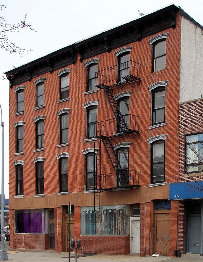
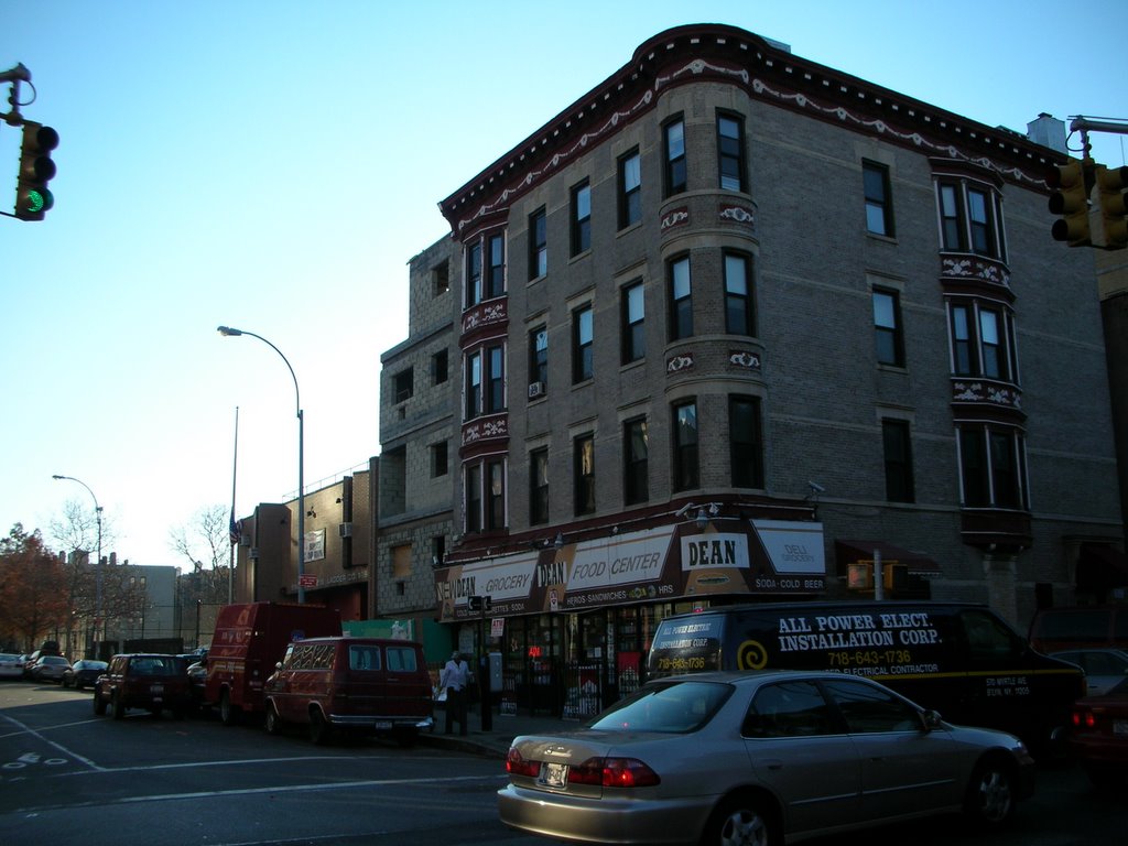
Dean Street at 6th Avenue, looking north. These buildings are slated for demolition to make room for the arena.
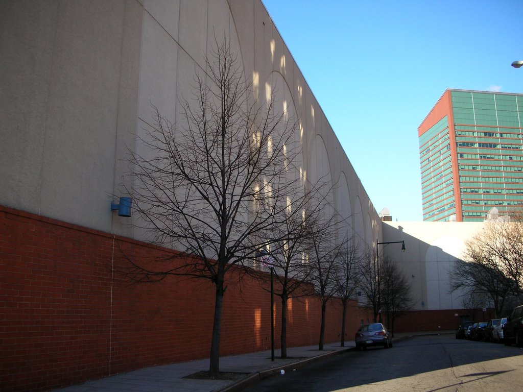
South Elliott Place at South Portland Avenue, looking south. This development by Forest City Ratner, not slated for demolition, sits directly north of the proposed arena and closer to mass transit.


