Sunday, February 19, 2006

Six Reasons to Close the Streets / Not!

The area formerly known as Pacific Street

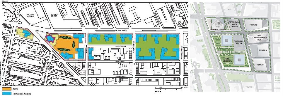
Last week, City Planning Chair Amanda Burden made a strong case for an open Cortlandt Street at the World Trade Center site. “We need our streets,” she said, “we need connectivity, we need an open Cortlandt Street for light and air and to create normal blocks”. But that’s Manhattan. Brooklyn is different. In Brooklyn, there are six reasons to close Pacific Street between Vanderbilt and Carlton. Lets review:

1. The blocks, as they stand, are not “viable development sites”.
This is one reason City Planning has given in the past for demapping streets in the Downtown Brooklyn Plan. But that was for combining small blocks. These are already huge blocks. And the plans show no buildings on the former street area.

2. Closing Pacific Street will allow for better vehicular circulation.
This is the other reason City Planning has given in the past for demapping streets in the Downtown Brooklyn Plan. Pacific Street is currently a very long, well used street. Since the proposed arena location requires Pacific to be closed between 6th Avenue and Flatbush, closing Pacific between Carlton and Vanderbilt will keep the remaining block between 6th Avenue and Carlton clear of through traffic, which would be diverted to Atlantic, Dean, Bergen, St. Marks Place and further south. Earlier plans (thank you wayback machine) did show vehicular entrances to below grade parking in line with Pacific, but the plans attached to the Memorandum of Understanding with the City don’t show that arrangement.

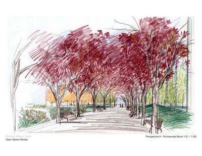
3. The street area can be used to make “open space”, as in “we are providing 6 acres of Publicly Accessible Open Space”.
But the streets are already open now. As Ms. Burden has pointed out about Lower Manhattan, “The public realm in New York is primarily composed of streets and sidewalks. As such, Dey and Cortlandt provide key opportunities to expand the amount of open space”. In fact, streets and sidewalks are the quintessential public open space in Brooklyn. We use these areas to plant trees, for our kids to play, to walk, jog, bike, skateboard, rollerblade, have stoop sales, meet our neighbors, walk the dog, and the street areas provide views, light and air to the adjacent built form. They connect our communities; they make our place.

4. Closing the street will provide more site, so more building can be constructed.
This is false. The total geographic area remains the same. Closing the streets only makes the site look bigger in FAR calculations, which would be a misuse of the intent of that measure.

5. Creating a super block at the east end of the site provides another possible location for the arena.
O.K., we’re stretching here. But it occurs to us that the currently proposed site for the arena may not work out. There may be infrastructure issues that make it impractical. The required taking of the properties may be unsuccessful. However, locating the arena at the east end of the site would stretch the arena crowds from the subway and railroad across the entire site, rendering the residential aspect less desirable. Relocating the arena would also require an updated Environmental Impact Statement, with attendant scheduling impact. Not likely, but don’t rule it out.

6. Closing the streets makes a great space.
And I have a bridge you may be interested in. Renderings can make any space look great, and Mr. Olin’s renderings are always spectacular. But look closely, beyond the colors. Look at what you don’t see. This is not a configuration of streets and blocks that an urban designer or an architect or the public could love; it’s a developer’s dream.

Tuesday, February 07, 2006

Demapping Planning

At the recent Brooklyn Borough Atlantic Yards Committee’s meeting, Winston Von Engel from City Planning was asked what the department’s position on demapping streets is. His initial reply: "I don't think there's one policy for demapping or mapping streets". Spectacularly unhelpful. And then, according to Norman Oder in the TimesRatnerReport, Von Engel continued:

"In Downtown Brooklyn, we demapped streets to create more rational building sites, more rational blocks, because the leftover remnants were not lending themselves to be building on. But in other cases, we've mapped streets back and we appreciate the life that streets bring. There is no one set policy."

OK, both happen. But that doesn’t mean that there is no policy. In fact there is a policy, and we know what it is: agree to demap streets only if doing so supports sound urban design principles. City Planning’s public silence in the wake of the planning failure at Atlantic Yards is uncharacteristically deferential to the developer, at the expense of the public realm. Was Von Engel’s statement that the city has supported demapping streets in Downtown Brooklyn a reference to the changes in the Downtown Brooklyn plan in which "several street map changes are proposed to create larger, more viable development sites, to improve traffic flow and to provide landscaped street medians. These actions include closing some low-volume streets and extending and widening some other streets", or the 2003 demapping of portions of Pearl and Adams Streets to expand the Brooklyn Marriott Hotel? There the 1,025 square feet at the end of Pearl was already a dead-end, used only for on-street parking. And the 3,395 square foot sliver of Adams was a non-traffic remnant of a 1940’s street widening. These actions are in no way similar to the proposed demapping of approximately 70,000 square feet of Pacific Street between Carlton and Vanderbilt.

Pacific is far from a low-volume street, or a short dead end street. And the blocks on either side are already very large, approximately 200 feet wide and 1000 feet long, certainly not irrational for building sites. Demapping this section of Pacific would form an enormous superblock of perhaps 470,000 sf, over 10 acres. In many ways, the issues here are similar to the issues at the former World Trade Center superblock. The Chair of the City Planning Commission and Director of the Department of City Planning, Amanda Burden, recently addressed those streets and blocks in an open letter to the LMDC:

“It is critical to the successful integration of the site with the rest of Lower Manhattan that Dey and Cortland Streets be extended as real streets between Church and Greenwich. These streets must be designed to accommodate both vehicular and pedestrian use. The public realm in New York is primarily composed of streets and sidewalks. As such, Dey and Cortlandt provide key opportunities to expand the amount of open space and accessibility into the site. Furthermore, these streets will ensure that the typical block size along Church Street remains the same as the blocks to the north and south. In New York, with few exceptions, larger block sizes…are provided only for our most significant public buildings such as Grand Central Station” .

But we clearly understood Von Engel’s remarks when he alluded to the support of the project by his boss’s boss. It’s unfortunate that this support is clouding a true discussion of the real urban design issues at stake.

Saturday, February 04, 2006

How Big Is It?


We’re not sure why it took us so long to realize we could just post the numbers. Then maybe we can give this FAR thing a rest. So get out your calculators and the Draft Scope, and check my figures:

The Draft Scope proposes a project of 9,132,000 sf (P.2, Table 1), and indicates that the site is 22 acres (958,320 sf.) (P.1). Therefore, the proposed FAR (roughly: building area divided by site area) would appear to be 9,132,000 / 958,320, for an FAR of 9.5. That's extremely dense, but wait, there’s more. In a
previous post, we calculated the total area of the streets taken by the project to be 133,000 sf. So the proposed FAR on the existing blocks (streets or no streets, the total building density on the land can in fact be compared to other areas) is 9,132,000 / (958,320 – 133,000), for an FAR of 11. Sit down, there’s still more. Because the arena (which appears to occupy about 85,000 sf of site area) will be built at a much lower FAR (lets say, conservatively, 2) the air rights over the arena will be used on the rest of the site. What would the resulting density be on the rest of the site? Subtracting 2 times the arena building area from the total building area, and dividing by the remaining site area (total site area less the arena facility footprint), (9,132,000 – (2 x 85,000) / 825,320 – 85,000 = 8,962,000 / 740,000 ), the FAR for the non-arena area of the existing site is, conservatively, over 12. So that’s the genius of the scheme: you can argue for an FAR of 9.5 (knowing it will get knocked down), but it really amounts to an FAR of over 12 on the 740,000 sf (17 acres) of non-arena site.

Let’s put this in perspective. On the World Trade Center site,
current plans call for about 8 million square feet of office space, and perhaps 500,000 sf of other program above grade, on 16 acres. It also happens to include the world's tallest building. That’s an FAR of 8,500,000 / 16 x 43,560 = 12.2. To our knowledge, there are no blocks in Brooklyn that would allow for an FAR of over 12. Currently only about a dozen blocks in our borough, 10% of the new Downtown Brooklyn plan at the very center, would allow for an FAR of over 10.

Does it matter? Let’s remember, the FAR is the best overall indication of demand on services, from utilities to transportation to emergency services to schools for residents. When do we get to see a revised project proposal that is not off-the-charts too big for its location in Brownstone Brooklyn, so that we can move on?


(Some assumptions are required here, especially concerning the footprint of the arena. Table 1 of the Draft Scope indicates that the arena size is 850,000 sf (?!). That is equivalent to 42 floors of a 20,000 sf floor plate. Is that a typo, or does it refer to the entire arena block, including the commercial development? We assume it’s the block, and that the footprint of the arena is 85,000 sf).